89 days until I start
Planning
How to start, how to get there, what you need to navigate
your way. The Route I plan to take. North Island, then the
South Island
Planning to ride New Zealand on a push bike (get it, “push…bike”) is an interesting exercise. There are specific books and guides, websites with downloadable GPX files (files you send to your GPS device to follow on your fancy bike computer), Facebook groups, websites, and YouTube videos. And then, there is always “someone knows a guy/gal that’s done it before.”
All information is at your fingertips, ready for you to try to make sense of it so you can plot and plan your journey.
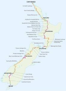
The official site to follow is Tour Aotearoa http://www.touraotearoa.nz (otherwise known as the TA). This is a great resource put together by the Kennett Brothers, who have, with great effort, created an official Route to guide you from Cape Regina to Bluff.
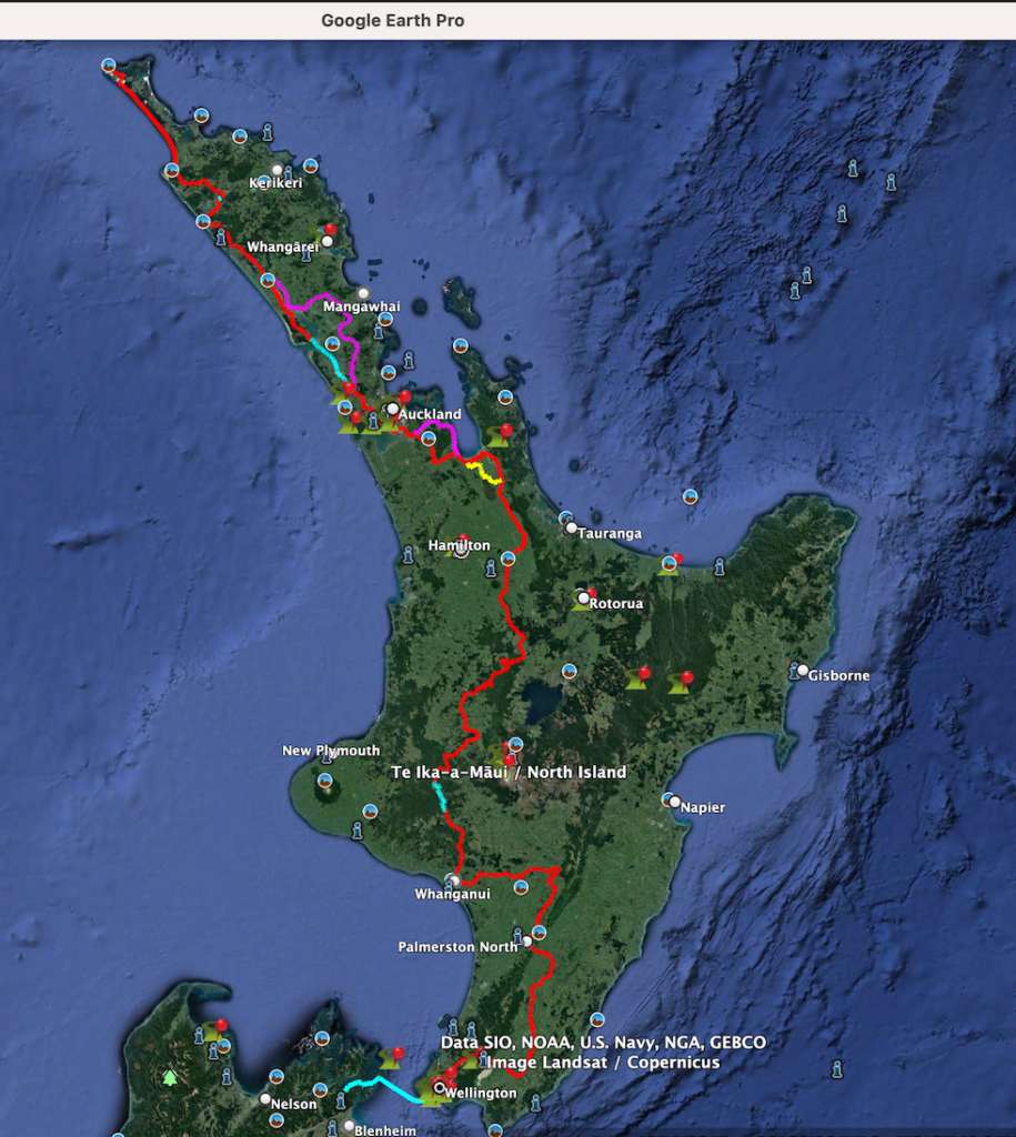
Which if you recall was the NZ Map from my first Post.
Here is a cool Google Earth of the North Island leg.
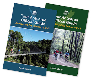
The Kennett Brothers have produced two books for the TA,
North Island and South Island.
Both are very well-put-together, detailed guides. Not just the track itself to follow but also handy information about camping, accommodation, shops, and local bike shops.
Their website is also a good resource.
These books are updated, with new editions being released (occasionally). They also make available PDF page updates of changes as they happen.
I bought these two books about four years ago. A lot has happened since then (hmmm, wonder what that was…) so a few things have changed with the parts of the Route. Tracks change, new routes appear, services change. But you know what really hasn’t changed?. The 3000km distance.
Many who know me don’t know that I read books. Regularly, like every night. However, can you imagine me holding a “Physical Book?”
Nope, I can’t. But I do read a Kindle.
And guess what works on a Kindle?
PDFs work.

Disclaimer: Those are not my Hands (You dummy) #duh
The TA book guides are available not only as two softcover guides but two PDFS as well. (@ $20 each)
This suits me since I’m accustomed to reading a Kindle.
I also mentioned the GPX files above. These are downloadable turn-by-turn digital navigation files of the official Route.
Like a GPS Navman – with downloadable street maps which you may have for your flash AF car (ok, I know its all iPhone maps now and CarPlay). Anyway, these downloadable GPX files are also Maps, but for your bike computer, with biking routes.
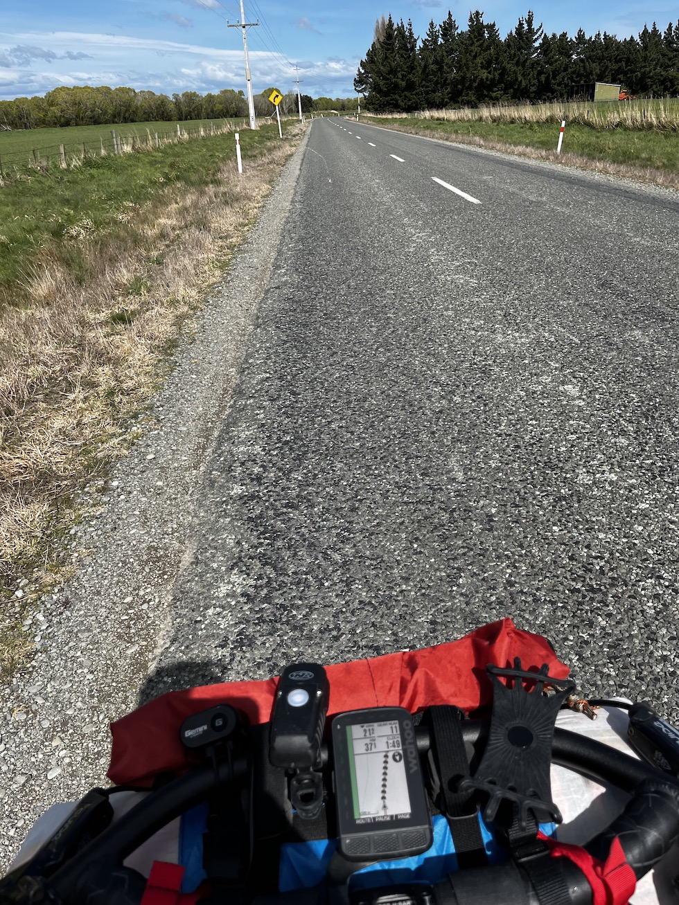
Your bike computer needs to be of decent quality to manage these files. The Bike Computer I use is a Wahoo Element Roam.
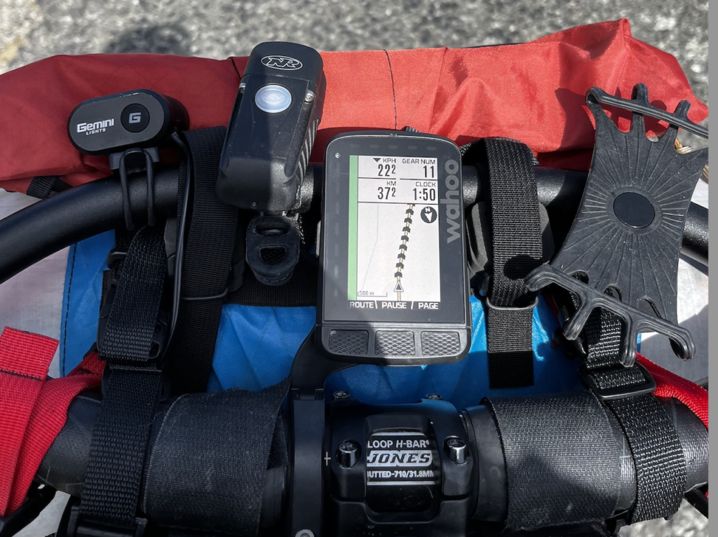
Most long-distance riders either use Wahoo or Garmin as their Bike Computer. (The cooler cats use Garmin)
So, there you go. I will be armed with two main sources of guides to follow.
Two PDFs on my Kindle to read, Each “next day ride” to study the night before, and then, as it happens, turn-by-turn Navigation in front of me on my Bike Computer,
What could go wrong?
HOLD MY BEER!
There is a twist to the South Island leg of my “epic” Journey instead of doing the TA route in the South Island, mainly the West Coast side. I was thinking instead of going down the East side of the South Island and crossing in through Central, coming out “maybe” Cromwell way.
This South Island (Over to the East Side, ends up on the West side) is commonly known as the Sounds to Sounds – (S2S), which I will only do part of, which just so happens to be another downloadable PDF for my Kindle.
This is where you start in Marlborough Sounds and finish up in Doubtfall Sounds (way) in Fiordland.
See the full Google map here: http://www.kennett.co.nz/maps/sounds2sound/
Instead, I will start in Picton on the Route to Blenheim and, many hundreds of km later, end up at the main turning point, Mavora, in Southland. Where I don’t continue to Manapouri way, I will go to Bluff via the Southern Traverse Route, which leads into Invercargill, and I’ll do the Bluff Finisher.
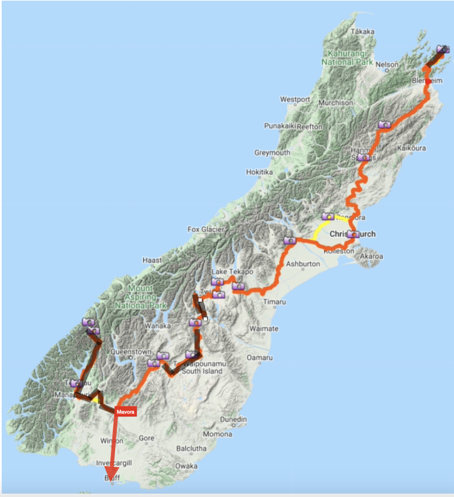
I also plan to go from Twizel to Cromwell via the main road, cutting out some of the S2S. Or, instead, I may detour straight into Wanaka (I like Wanaka) and go to Queenstown via the Crown range.
However, it is just a first draft plan and will firm up the closer I get to the end of this year.
Hey not finished, you are forgetting something!
How to get to Cape Regina
Well, here is our official first hurdle. And I say “our” because even though this ride is unsupported, it is very supported by Shani and Fam just to get started.
The plan started with a Holiday in Mangawhai for Christmas 23. Where the Aklnd Family were coming in, and we’ll all hang out together (actually in the Aklnd Family Mangawhai beach house, it’s like who you know, right!)
The initial thought was to use the Rental SUV to get to Mangawhai from Auckland Airport and then to Cape Reinga with the Bike on the back.
After booking – I asked the Car rental place about Tow Bars for bike racks, and it turns out that no rental companies offer tow bars for their vehicles.
I can get the Bike (boxed) on the plane (it goes on as normal luggage has to be in one of their approved bike boxes I got an AIR NZ one, and it needs to be under 23kg in weight. No batteries, Co2 canisters, and you need to deflate your bike tires of air.) But at Auckland Airport, that’s as far as it can go. (well, not really, but it sounds dramatic enough)
Biking from Auckland Airport to Mangawhai is 122km, then from Mangawhai to Cape Regina it is 337km. Even though this is my preference, we did manage to sort it (As a plan, it hasn’t happened at the time of writing), so I won’t be biking from Auckland 🙁 (I was truly excited about doing that!)
– seriously, I mean, whats a an extra 122km + 337km on top of “I’m about” to do 3000km from next week. It’s called Gains man, GAINZ.
Car Rental companies in NZ should have tow bars on their vehicles (at least a SUV type). I mean, are we not supposed to be a Country for Adventurers?
Sort it out NZ Car Rental Peeps!
Stay tuned.
My next post is going to be about my fitness build up, to be able to physically do this ride. And I can 100% confirm right now for the record but to also put your mind at ease, there was no bloody Zumba involved.
Hey You! Are you New to this Blog?
Find and read below the series of Posts. Listed Top down, oldest to newest.
-
Riding New Zealand
The first reaction I generally get when I (or others) tell someone I’m going to ride NZ is, WTF are you crazy? It seems like an impossible feat for nonbikers, right? It stands out as a holy grail achievement, even for those who cycle.(I’m not taking that away from any […]
-
Planning “To Ride NZ”
89 days until I start Planning How to start, how to get there, what you need to navigate your way. The Route I plan to take. North Island, then the South Island Planning to ride New Zealand on a push bike (get it, “push…bike”) is an interesting exercise. There are […]
-
Training “To Ride NZ”
82 days until I start Shouldn’t you start training for this? This is what I kept getting asked. And it is a fair question, so thank you for your support.But, me peeps! I’ve been training for 30-odd years, so I’m good. I’ve also been eating some donuts, but who counts […]
-
Bike / Gear Prep ‘Part One’- Riding NZ
75 days until I start You have to consider several things when going on a multiday ride. What type of bike should you ride for these adventures, how does that Bike need to be set up, what gear do you need to take, and how do you carry all this […]
-
Bike / Gear Prep ‘Part Two’- Riding NZ
68 days until I start Part Two brings us to the how and what I will carry but also the Why How? – how do you carry everything except for the Stainless Steel Kitchen Sink (joking, We have a Butlers Sink in our Kitchen and that bitch is heavier […]
-
Nutrition! Coffee Sponsorship – Riding NZ
62 days until I start Fact: Based on my last seven big 100km+ rides, “little” ole me is burning, on average, 5000 calories per Ride. How do I know this? Well, move in closer, me-friend; let me tell you some stuff. I wear a Myzone heartrate monitor that connects to my […]
-
Mehhh-hanicals
53 Days until I start Yeah, you read that one right. “Mehh-hanicals,” otherwise known in the English language as “Mechanicals.” Oh Boy, oh Boy.Things were going good until about 40ish km in, and I must have rolled over a nail to receive a special gift from the “Roads of Winton” […]
-
Off Bike – Working Remotely – Bike Update
49 Days Until I Start Part of my planning was to work out what to do when I wasn’t riding.Being (OCD) Bike Cautious, I’m not about to stray too far from my main form of transport.I’m intellectually and very rudimentary ‘not-so-smart” even to work out how to play Sudoku, or […]
-
Tracking – Riding NZ
42 Days until I Start. Remember back in the 1800s when you pondered over hand-drawn maps by candlelight to get excited about your up-and-coming horse-and-cart journey through the unforsaken lay of the land to get to a better life? Yeah, me neither. What about in the mid-late 1900s when you […]
-
Almost D-Day
I’ve been off the bike for a few weeks, which is why posts have stopped. I find being on the bike has been the perfect time to think about what to write, but off bike, not so much. Since the last post, I arrived in Auckland with a Bike in […]
-
A Week of the TA, quick summary of each day.
Running totals: 683 km completed, 35,562 calories burned, elevation climbed 5070 meters, 48:58 hours in the Saddle. Shuttle from Kaitaia to Cape Regina, then about 9 am, I plundered down a 90-mile beach and ran out of water (I carry two ltrs, so I need to carry more). The kindness of strangers topped me up […]
5 thoughts on “Planning “To Ride NZ””
Comments are closed.